


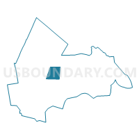
TOWN OF FREMONT Voting District, Rockingham County, New Hampshire
About
Outline

Summary
| Unique Area Identifier | 616451 |
| Name | TOWN OF FREMONT Voting District |
| County | Rockingham County |
| State | New Hampshire |
| Area (square miles) | 17.39 |
| Land Area (square miles) | 17.11 |
| Water Area (square miles) | 0.28 |
| % of Land Area | 98.39 |
| % of Water Area | 1.61 |
| Latitude of the Internal Point | 42.99985650 |
| Longtitude of the Internal Point | -71.11971350 |
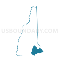
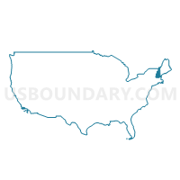
Maps
Graphs
Select a template below for downloading or customizing gragh for TOWN OF FREMONT Voting District, Rockingham County, New Hampshire


Neighbors
Neighoring Voting District (by Name) Neighboring Voting District on the Map
- TOWN OF BRENTWOOD Voting District, Rockingham County, NH
- TOWN OF CHESTER Voting District, Rockingham County, NH
- TOWN OF DANVILLE Voting District, Rockingham County, NH
- TOWN OF EPPING Voting District, Rockingham County, NH
- TOWN OF KINGSTON Voting District, Rockingham County, NH
- TOWN OF RAYMOND Voting District, Rockingham County, NH
- TOWN OF SANDOWN Voting District, Rockingham County, NH
Top 10 Neighboring County Subdivision (by Population) Neighboring County Subdivision on the Map
- Raymond town, Rockingham County, NH (10,138)
- Epping town, Rockingham County, NH (6,411)
- Kingston town, Rockingham County, NH (6,025)
- Sandown town, Rockingham County, NH (5,986)
- Chester town, Rockingham County, NH (4,768)
- Brentwood town, Rockingham County, NH (4,486)
- Danville town, Rockingham County, NH (4,387)
- Fremont town, Rockingham County, NH (4,283)
Top 10 Neighboring Elementary School District (by Population) Neighboring Elementary School District on the Map
Top 10 Neighboring Secondary School District (by Population) Neighboring Secondary School District on the Map
Top 10 Neighboring Unified School District (by Population) Neighboring Unified School District on the Map
- Timberlane Regional School District, NH (24,733)
- Sanborn Regional School District, NH (10,628)
- Raymond School District, NH (10,138)
- Epping School District, NH (6,411)
- Fremont School District, NH (4,283)
Top 10 Neighboring State Legislative District Lower Chamber (by Population) Neighboring State Legislative District Lower Chamber on the Map
- State House District 8, Rockingham County, NH (22,157)
- State House District 7, Rockingham County, NH (15,141)
- State House District 9, Rockingham County, NH (10,694)
- State House District 2, Rockingham County, NH (10,138)
- State House District 10, Rockingham County, NH (4,486)
Top 10 Neighboring State Legislative District Upper Chamber (by Population) Neighboring State Legislative District Upper Chamber on the Map
- State Senate District 17, NH (58,086)
- State Senate District 21, NH (57,893)
- State Senate District 23, NH (56,793)
Top 10 Neighboring 111th Congressional District (by Population) Neighboring 111th Congressional District on the Map
Top 10 Neighboring Census Tract (by Population) Neighboring Census Tract on the Map
- Census Tract 590, Rockingham County, NH (6,411)
- Census Tract 1051, Rockingham County, NH (6,025)
- Census Tract 520, Rockingham County, NH (5,986)
- Census Tract 550.01, Rockingham County, NH (5,944)
- Census Tract 510, Rockingham County, NH (4,768)
- Census Tract 600, Rockingham County, NH (4,486)
- Census Tract 530, Rockingham County, NH (4,387)
- Census Tract 540, Rockingham County, NH (4,283)
Top 10 Neighboring 5-Digit ZIP Code Tabulation Area (by Population) Neighboring 5-Digit ZIP Code Tabulation Area on the Map
- 03833, NH (20,955)
- 03077, NH (10,155)
- 03042, NH (6,341)
- 03848, NH (6,020)
- 03873, NH (5,711)
- 03036, NH (4,782)
- 03819, NH (4,377)
- 03044, NH (4,263)